Friday, 15 March 2019

Framborough (chalk bed, glacial deposit, coastal erosion)

Framborough (East Riding of Yorkshire)  7 July, 2018

Keywords: Beach, Chalk bed, Till, Quaternary
*See Bridlington about the coastal erosion here !

I visited Framborough to observe chalk bed, till and coastal erosion.

Fig. 1. Locality of Framborough.
Framborough is located on the headland in the eastern coast of Britain Island (Fig. 1).


The headland consists of the Cretaceous chalk beds (Fig. 2). We can observe the beds in the coastal cliff.

Fig. 2. Chalk bed with white color in Framborough.
We can observe till deposited Quarternary over the chalk beds (Fig. 3). This is my first time to observe till and glacial deposits which is difficult to find in Japan because glacial didn't develop in Japan during glacial stages in Quarternary.

Fig. 3. Till over the chalk bed.
The till consists of gravel, sand and silt without structures (Fig. 4). The base, contact with chalk beds, are erosional surfaces which are undulated (Fig. 5).
Fig. 4. Close-up of till.
Fig. 5. Contact between chalk bed and till.

In Japanese case, fluvial or shallow marine deposits with tephra are distributed on surfaces of many coastal areas. From the sedimentary environment and the depositional ages using tephra and the altitude, we can reconstruct tectonic, paleo sea-level and geological histories of the area. The activities of some active faults in Japan which can occur earthquakes in near future are estimated based on this method. I am also using it in Japan but I feel that it is difficult to apply the method to the Quarternary which consists of glacial deposits in UK because the method requires the altitude of paleo plain-surfaces or deposits which were formed under strong influence by sea level, for example beach or tidal flat, as indicators of paleo sea-level. The difference of the altitudes of basal erosional surfaces, by river or wave, of other glacial stages is also useful to reconstruct tectonic history but erosional surfaces of glacial seems to be independent from sea level.
In addition to this, we have to consider about post-glacial rebound occurred in UK (Western Europe and North America, birthplace of and pivotal areas for geology) to reconstruct the tectonics.

Withernsea (offshore wind power, coastal erosion)

Withernsea (East Riding of Yorkshire)  1 Sep., 2018

Keywords: Offshore wind power, Coastal erosion

I visited Withernsea to see offshore wind turbines and to observed coastal erosion (Fig. 1).
Fig. 1. Locality of Withernsea.

Many wind turbines were lined up off the coast of Withernsea (Fig. 2). I could see at least hundred turbines with sevral hundred of meters interval.
Fig. 2. Many wind turbines off Withernsea.


It seems to be difficult to fishing in the area. In Japan, inshore fishery is active in many coastal areas so coexistence with fishery will be one of the subjects for Japanese offshore wind industry, I think.

The coast of Withernsea is protected from coastal erosion by levee and large stones (Fig. 3).
Fig. 3. Northern coast of Withernsea.

On the other hand in coast around the town, there are no levee and severe coastal erosion is in progress (Fig. 4). Some houses and roads were lost due to the erosion (Fig. 5).
Fig. 4. Southern coast of Withernsea.

Fig. 5. Satellite image of the southern coast of Withernsea.

The coastal cliff is consisted of till and we can find many landslide surfaces (Fig. 6). But there are no landslide deposits or talus in the bottom of the cliff. They will probably be eroded easily by wave during high tide when the beach in front of the cliff is submerged. In Japan with micro-tide, most of beach is not submerged entirely even during high tide. I think I need to pay more attention to tidal range when I discuss about coastal erosion.
Fig. 6. Till outcrops the coastal cliff.


Birmingham and Nottingham (redeveloped canal, fluvial deposit)

Birmingham and Nottingham (Midland) 29 Oct. to 30 Oct., 2018

Keywords: Canal, Redevelopment, Fluvial deposit

I visited Birmingham and Nottingham in Midlands on the way home from Cardiff and saw the canals and sandstone there (Fig. 1).


Fig. 1. Localities of Birmingham and Nottingham


Birmingham is the second-most populous city in the United Kingdom and important city of traffic because of the canal and train, especially after Industrial Revolution. I couldn't found the interesting things in geology during my two hours visit but found the canal redeveloped to stylish shopping area from coal transport ways (Fig. 2) like Cardiff Bay. It will be important to prevent mud deposition if canal is used for transport. Geologist can tackle the subject. But now, how can geologist contribute to such a redeveloped canal ?


Fig. 2. The canal redeveloped to stylish shopping area in Gas street basin. Cafes and pubs are located along the canal. Some small cargo ships are in business as pubs on the canal.


Nottingham is famous for the legend of Robin Hood. I visited there to observe Castle Rock which is type section of Early Triassic Nottingham Castle Sandstone Formation (Figs. 3 and 4). The sediment is located base of Nottingham Castle and fluvial deposit which is consist of sand and gravel with cross bedding.
Fig. 3. Nottingham Castle Sandstone Formation at the base of Nottingham Castle.

Fig. 4. Nottingham Castle Sandstone Formation. Beautiful cross bed is developed.

Thursday, 14 March 2019

Cardiff Bay (tidal flat, huge port with water gate)


Cardiff Bay (Wales)  27 Oct., 2018
Keyword: Estuary, Port redevelopment, Water gate

I visited Cardiff to observe Cardiff Bay faces to Bristol Channel. I was expecting to observe a natural macro-tidal estuary with beautiful sedimentary structures and bedforms. But I could see artificial huge dam lake there.

Cardiff is capital of Wales and located in front of Cardiff Bay which faces to Bristol Channel and has developed as a port to export coals after Industrial Revolution (Fig. 1).
Fig. 1. Locality of Cardiff Bay.

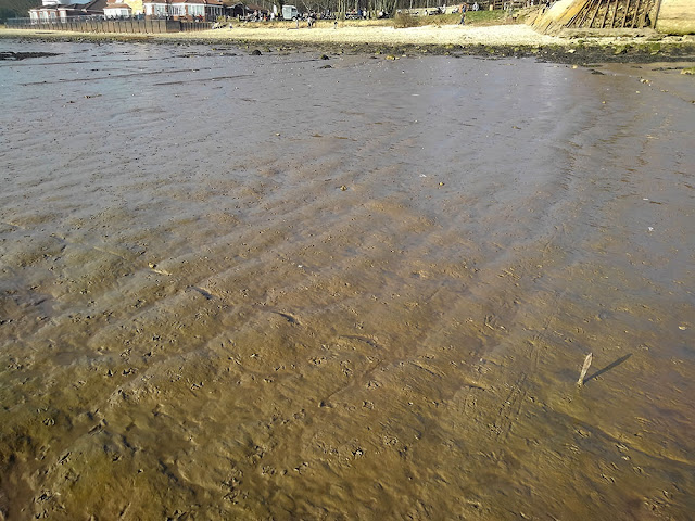
I visited the city but there were few things to see from a view point of sedimentology. So I moved to Penarth, south of Cardiff Bay, to observe beach faces to Bristol Channel with about 8 m in tidal range. Mainly gravel are distributed in the beach (Fig. 2) and mud and sand were partially distributed (Fig. 3). Ripple was developed only on sand and muddy areas were slightly higher than other areas (Fig. 4). It is very interesting how these sediment with various grain size transported and distributed like this.

Fig. 2. Beach of Bristol Channel in Penarth, south of Cardiff.
Fig. 3. Gravel and mud were distributed.
Fig. 4. Ripple was developed only on sandy areas and muddy areas were higher.

Sedimentary rock was outcropped at the cliff in back of the beach (Fig. 5).


Fig. 5. Sedimentary rock in Penarth, south of Cardiff.

The cliff is very dangerous because I saw the rocks with human-head size fallen from the cliff many times during my only two hours visit and probably supplies many gravels to the beach. The sediment seems to have wave ripple and shell beds but I couldn't observe the sediment in detail because of fallen rocks.


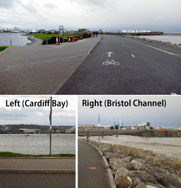
After the observation of the beach, I walked to Cardiff Bay along the beach and was surprised. There were huge levee (Fig. 6) and I saw beautiful clear blue water inside the gate(Fig. 7). Cardiff Bay is completely separated from Bristol Channel by huge levee (Fig. 8).

Fig. 6. Levee in Cardiff bay. Three people on the levee.
Fig. 7. Inside (lower left) and outside (lower right) views of the levee in Cardiff Bay
Fig. 8. Satellite image of Cardiff Bay.

There are marina and people enjoy marine sports inside the levee. People also enjoy running and cycling on the levee, shopping and dinner in shopping mall and pub around the "bay". The "bay" was redeveloped to a stylish water front resort from a port for coal export after 1980's.
To observe tidal flat is as enjoyable as marine sports and shopping, I think (maybe many people don't agree with) .

Wednesday, 13 March 2019

Hartlepool (beach, washover fan)

Hartlepool (County Dorham)  1 Mar., 2019

Keywords: Beach, Sedimentology, Washover fan

I visited Hartlepool for research meeting and observed beach there on the way.

Hartlepool is located along the east coast of Britain Island and faces the North Sea. The town has developed from the 7th century around the abbey in Headland which is a spit, and large port is located at the base of the spit (Fig. 1).


Fig. 1. Locality of Hartlepool. In the northern coast of Hartlepool, there two or three rows of longitudinal bars in front of beach.

The North Sea side of Headland is a rocky (Fig. 2), and there is a sandy beach on the north side (Fig. 3), and I observed the sandy beach.
Fig. 2. North Sea side coast of Headland (Eastern coast of Hartlepool).


Fig. 3. Northern coast of Hartlepool.

According to satellite images (Fig. 1), there are two or three rows of longitudinal bars on the beach but most of them were submerged except for the bar described later because I visited there during high tide. The waves were breaking several hundred meters off the coast, so there is probably a bar there (Fig. 4).


Fig. 4. Wave break on submerged bars several hundred meters off the coast.
A bar was exposed several hundred meters north of Headland (Fig. 3). The surface was flat for the waves to be washed, and the crescent-shaped scours developed on the seaward side of gravels on the sand (Fig. 5).
Fig. 5. Surface of the bar.


There are low points in the bar every several tens meters, and the great waves pass through it to runnel which is the water area located between the bar and foreshore (Fig. 6). 

Fig. 6. Timelaps pictures of washover. Left: whole view. Right: close view.
This washover occurred as often as once every few minutes. It is closer to the actual situation that the great waves beyond the top of the bar change to sheet flows and flow down to the runnel, rather than the waves just passing over. Channels with low relief were formed when flowing down, more water flow concentrated to there and was further developed, and fans were formed on the runnel side of the bar.

In addition, in places where waves reach once in a few minutes, air bubbles from sand immediately after the waves are covered, leaving holes of about 2 mm in diameter (Fig. 5).

Tuesday, 12 March 2019

River Medway (mud flat, port in river)

River Medway (Kent)  28 Jan. to 29 Jan., 2019

Keywords: Tidal flat, Sedimentology, Land use, Port


I visited the mouth of River Medway to observe mud flat and the port along the river.
First, I went to Gillingham where a wide tidal flat spreads along the riverbank (Fig. 1).
Fig. 1. Location of River Medway.
The tidal range is around 5 m and the seafloor of the port was exposed when I visited there in low tide stage (Fig. 2). Meandering creeks develop in the tidal flat (Fig. 3), and dune develops (Fig. 4).
Fig. 2. Exposed seafloor in port.
Fig. 3. Meandering creeks and dune on the mud flat.

Fig. 4. Dune on the mud flat.

And I walked along the river to St. Mary's Island. It is not an typical island, but isolated point bar separated by a water channel (Fig. 5). There are four passages to the island, and all are water gates, and the water areas between them are used as marina or dock with the water level kept constant (Fig. 6).

Fig. 5. Location of St. Mary's Island.
Fig. 6. Marina inside the water gate. The water level then in marine is few meters higher than outside.
Many British important ports, included the port around here, are located at places where estuary changes nallow and to a meandering river like here. And most of the ports have water gates to keep water level constant.
On the other hand in Japan, the most of important ports are located along the sea and few are located along the river. In addition to this, Japanese ports are protected from strong wave and tsunami not water level changes due to tide. The differences are because tidal range is small and the river traffic is less developed due to the large river gradient in Japan, I think.
Navigation management is pointed out as a purpose in many international research papers about mud deposition in estuaries (and rivers). But in Japan, it seems not to be necessary in many rivers so I couldn't realize the importance before I saw such a ports in UK rivers.
The island is a high-end residential area, with many herbs planted along the garden and the road, with a lavender scent. The island is like a paradice (Fig. 7).
Fig. 7. Residential area in St. Mary's Island.
Along the island, River Medway is clear and blue, but the shore is a mud flat with ripple and a creeks which are perpendicular to the river. Many yachts are anchored on the river (Fig. 8).
Fig.8. River Medway and the mud flat on the shore.
I continued to observe along the river to Rochester, I found the small-scaled cuesta developed on the mud flat (Fig. 9).

Fig. 9. Small-scaled cuesta on mud flat. Strata are inclined steeper toward the river than present river bed.


The bedding surface of the sediments which are also modern are inclined steeper toward the river than the present river bed. To make such a structures, it have to be flatter at the erosional phases than depositional phases. Many cuesta in mud flat are opposite (only my experiences) so I felt this structure unusual.
It would be interesting to reconstruct the geological history by conducting a columnar sampling.


Appendix

As this area is a key area of transportation, it is also important for the military, and there are some forts, for example, Rochester Castle built in the 11th century and some early modern forts (Fig. 10).

Fig. 10. Forts around Rochester and Gillingham.


These buildings are open to the public and can often climb towers in many cases. From there, we can look quite far in all directions, and it helps to find out the places to observe, such as the distribution of outcrops, and glasp the summary of the topography (Fig. 11).

Fig. 11. View from Rochester Castle. The summary of River Medway and distributions of outcrops of chalk beds (right in the photo) are easily understand from here.

Rochester Castle is a tourist site not a geological site, so I visited there after I finished geological survey, but it was regrettable that if I went there in the beginning, I could grasp the whole picture before survey. After this survey, I decided to visit cathedrals or castles which are highest buildings in each area when I arrive new areas.

Humber (mud flat)


Humber (East Riding of Yorkshire)  24 Feb., 2019

Keywords: Tidal flat, Bedform, Sedimentology


I visited Humber to observe mudflat.
Humber is large estuary on the eastern coast of Northern England (Fig. 1).

Fig. 1. Location of Humber River.

I observed the northern tidal flat near Humber bridge in Hessle. Gravel beach, marsh, gravel and mud flat, mud flat and gravel and mud flat are developed there from land to river (Fig. 2).


Fig. 2. Whole view of tidal flat of Humber and Humber bridge in Hessle. Gravel beach, marsh, gravel and mud flat, mud flat and gravel and mud flat are developed from land to river.


Some bedform and structures are developed on the mud (Fig. 3).

Fig. 3. Bedform or surface structures on the mud. The structures are perpendicular to the river on the landward side (right)(see Fig. 4 for detail) and parallel to the river on the riverward (left)(see Fig. 5 for detail).
On the landward side, dune-like structures which oriented perpendicular to the river developed (Fig. 4). The wave length is around 40 - 60 cm and the height is less than 5 cm. These structures are small channels and may be originated from dune.


Fig. 4. Dune-like structures on the mud in landward side.
On the other hand in the riverward side, small-scaled cuesta which is parallel to the river is developed (Fig. 5).

Fig. 5. Small-scaled cuesta on the mud in the riverward side.


It seems to be formed by erosion in water front and alternated beds due to tidal cycles (Fig. 6).

Fig. 6. Close up of water front. Wave erodes the mud and makes stepped structures.


The boundary of these areas with different structures are clear. It is interesting research topic to clarify what control the differences and the boundary.