Norfolk Coast (Norfolk) 5 March to 7 March, 2019
Keywords: Beach, Sand flat, Mud flat, Bedform, Sedimentology
I visited Norfolk Coast to observe tidal flat and beach.
 |
| Locality of Norfolk Coast. |
Firstly, I visited Brancaster. I could observe the broad salt marsh and mud flat along the promenade (Norfolk coast path) which is on levee to protect the reclaimed land and located next to the main road of the town (A149).
In this marsh and mud flat, We can observe many sedimentary processes as below. I was deeply moved because this was first time to see broad salt marsh which is rare in Japan today although it is often found from ancient sediments.
 |
| Salt marsh along the Norfolk coast path. Most of this area is submerged during high tide. |
 |
| Promenade in salt marsh. |
 |
| Mud flat in salt marsh. |
 |
| Meandering channel in mud flat. |
 |
| Tide pool in salt marsh. There are many burrows. See next figure. |
 |
| Close-up of burrow. Feces of polychaetes. |
 |
| Norfolk coast path on levee. Left: salt marsh. Right: reclaimed land. |
 |
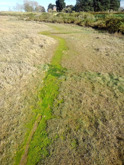
| Norfolk coast path. The way people walk is covered with moss without grass. Fantastic ! |
Second, I visited Wells-next-the-Sea. From this town, we can easily access to sand flat and beach. In this area, we can observe many kind of bedforms, current and wave ripple, wind ripple which are very useful indicaters of water or wind current when they were formed. The grain size of the ground is various and water current and wave are also various due to the interference of tidal current and local topography. So this may be suitable field to discuss about the effects of grain size to bedform.
 |
| Map of Norfolk Coast. Yellow areas are sandy areas, brown areas are muddy areas. |
 |
| Flat-topped ripple in sand flat. |
 |
| Close-up of flat-topped ripple. Exactly the same to textbook ! I firstly saw it although I sometimes describe it in ancient sediment. |
 |
| Variation of direction of ripple crest. left side (landward) is parallel to the channel but right side (seaward) is perpendicular. Left ones are wave ripple and right ones are current ripple ? |
 |
| Flat-topped ripple perpendicular to coast line. |
 |
| Transition zone of ripple with two type of directions. |
 |
| Ripple only in sandy area. Mud prevent ripple development ? How did mud distributed like this ? |
 |
| Close-up of muddy area. |
 |
| Close-up of sandy area. |
 |
| No ripple on mound. |
 |
| Ripple and sand dune in left with white color. |
 |
| How can we get the information about the paleo water-current from such a ripple ? |
 |
| White dry sand transported by wind deposits around obstacles. |
 |
| Ripple with stepped slope. Is it a result of erosion during falling tide ? |
 |
| Secondary crests in seaward side of ripple. |
 |
| White and dry sand is transported by wind from sand dunes and covers the wet and brown sand in beach. |
 |
| White sand is supplied by wind from sand dune. |
 |
| Erosional structures by wind. |
 |
| Close-up of erosional structures. |
 |
| Sand (white) transported by wind deposits on upwind side of wave ripple. |
 |
| Wave ripple is changing to wind ripple ? The wind is from lower to upper in this photo. |


